ちずぬりえとは
歩いた街が色になる、GPS 白地図ぬりつぶしゲーム
「ちずぬりえ」は、日本の白地図を自分の足で塗りつぶしていく、ブラウザでそのまま遊べる 無料のゲームです。GPS で現在地を取得すると、いま立っている場所の「約1km四方のマス」に 色が付きます。通勤・通学・散歩・旅行——ふだんの移動がそのまま記録になり、 地図の上に「自分が歩いてきた軌跡」が塗り絵のように広がっていきます。
アプリのインストールや会員登録は不要で、スマートフォンやパソコンのブラウザで開くだけで すぐに遊び始められます(ゲストとしてプレイ可能)。アカウントを登録すると、 塗った地図やポイントを別の端末でも引き継げます。
スクリーンショット
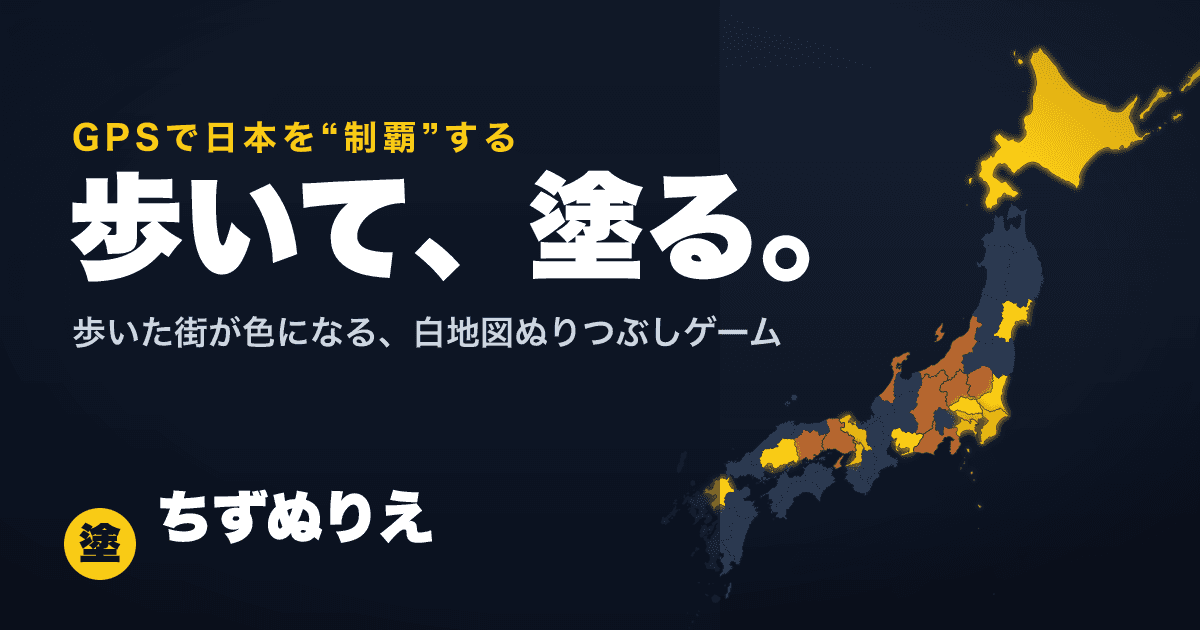
白地図の上に、訪れた場所・選んだ場所が約1km四方のマスで塗られていきます。
特徴
- 歩くだけで地図が塗れる:GPS で現在地のマスを無料で塗れます。実際に訪れた場所は「訪問済み」として特別に記録され、 経験値ボーナスももらえます。
- 約1km四方の公平なマス:塗りの単位は全国どこでも同じ広さの約1km四方のグリッドです。都会でも地方でも、 1マスは1マス。コツコツ塗った分だけ確実に地図が埋まります。
- 市区町村の「制覇」:市区町村ごとに塗り%(塗ったマス数/全マス数)が表示され、100% に到達するとその 市区町村を「制覇」。さらに都道府県の完全制覇も目指せます。
- ポイントとレベル:行けない場所は「塗りポイント」を使って手動でも塗れます。塗るほど経験値がたまり、 レベルが上がるとポイントの上限が増えていきます。
- ランキング:塗ったマス数を全国のプレイヤーと競えます。全体ランキングのほか、都道府県別・国別の ランキングもあります。
- 世界も塗れる:日本の外も同じ約1kmマスで塗れます。海外旅行の足あとも、国・州ごとの塗り%として 記録されます。
- ブラウザだけで動く・PWA 対応:インストール不要。ホーム画面に追加すればアプリのように全画面で遊べます。
使っている地図データ
地図・行政区域のデータには、次の公的・オープンなデータを加工して利用しています。
- 国土交通省「国土数値情報(行政区域データ)」(市区町村の境界)
- 総務省統計局 e-Stat「国勢調査 小地域データ」(町丁目の境界)
- 国土地理院 地理院地図(背景地図のオーバーレイ表示・住所の逆ジオコーディング)
- Natural Earth(世界版の国・州の境界)
さっそく遊んでみる
遊び方の詳しい説明は遊び方ページにまとめています。まずは地図を開いて、 GPS ボタンを押してみてください。いまいる場所に最初の色が付きます。
About Chizunurie
A GPS map-painting game where the streets you walk turn into color
Chizunurie (“map coloring” in Japanese) is a free game you can play right in your browser: a blank map of Japan that you fill in with your own feet. When you share your GPS location, the roughly 1 km × 1 km cell you are standing in gets painted. Commutes, walks, errands, trips — your everyday movement becomes a record, and the map slowly fills with color like a coloring book of everywhere you have been.
There is nothing to install and no sign-up required — just open the site on your phone or computer and start playing as a guest. If you create a free account later, your painted map and points carry over to any device.
Screenshot
Places you visit or choose are painted on the blank map as roughly 1 km square cells.
Features
- Paint the map just by walking: painting the cell you are standing in with GPS is free. Places you actually visit are specially recorded as “visited” and earn bonus experience points.
- Fair, equal-sized cells (about 1 km square): the painting unit is a uniform grid that is the same size everywhere. One cell in central Tokyo is worth the same as one cell in the countryside — steady walking always fills the map.
- Conquer municipalities: each city, town and village shows a painted percentage (painted cells / total cells). Reach 100% to “conquer” it, and conquer every municipality to fully conquer the prefecture.
- Points and levels: places you cannot reach can be painted manually using paint points. Painting earns XP, and leveling up raises your maximum points.
- Rankings: compete on painted-cell counts with other players — overall, by prefecture, and by country.
- The whole world is paintable: outside Japan the same ~1 km cells apply, and your travels are tracked as painted percentages per country and state.
- Browser-only, PWA-ready: no install needed. Add it to your home screen to play full-screen like a native app.
Map data sources
The maps and administrative boundaries are built from the following public and open data:
- MLIT “National Land Numerical Information” (municipal boundaries)
- Statistics Bureau of Japan, e-Stat census small-area data (neighborhood boundaries)
- Geospatial Information Authority of Japan (GSI) maps (base-map overlay and reverse geocoding)
- Natural Earth (country and state boundaries for the world map)
Jump in
The full rules are on the How to play page. To start, just open the map and tap the GPS button — your first cell gets its color right where you are.